


وصف لـ AirMate
Airmate is a free and easy to use application for pilots, providing help for flight planning and navigation, and including many social sharing features.
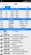
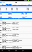
Thanks to Airmate flight planning tools, you will get instant access to airport data and aviation maps worldwide and up to date weather and NOTAMs.
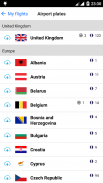
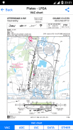
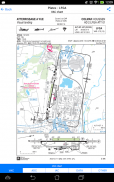
IFR and VFR airport plates are freely available in US (FAA charts), all Europe, and more than 200 other countries. Many of them are georeferenced and could be overlaid on the aviation chart. A powerful Plate Manager allows to download in advance all airport plates in a country, they could be easily printed and viewed.
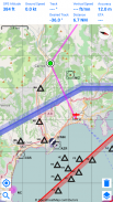
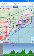
During the flight, the moving map will display the aircraft location along the route, show airports and aeronautical data details. A profile view is available to display terrain elevation across the route. Airmate includes a worldwide aeronautical database updated free of charge with airports, navigation beacons, waypoints, airways, regulated and restricted areas. Topographic maps and elevation data for most countries may be downloaded free of charge, as well as additional aviation map overlays such US Sectionals.
Airmate will also record your flights and allow to replay them later or export the flight path in gpx format.
A Satellite map display mode in flight planning or replay mode allows to familiarize with significant landmarks.
Airmate will save planned and flown flights, user waypoints and user aircrafts in the cloud and sync them between your devices.
Airmate brings numerous social features to the community. Pilots may leave ratings, tips and comments to share their experience with fellow pilots, and report fuel prices and landing fees. They could find friends, instructors, flight schools, aviation events and aircraft to rent near their home airport or any visited airport.
Airmate هو تطبيق مجاني وسهل الاستخدام للطيارين ، ويقدم المساعدة لتخطيط الرحلات الجوية والملاحة ، بما في ذلك العديد من ميزات المشاركة الاجتماعية.
بفضل أدوات Airmate لتخطيط الرحلات ، ستحصل على إمكانية الوصول الفوري إلى بيانات المطار وخرائط الطيران في جميع أنحاء العالم وتحديث الطقس و NOTAMs.
تتوفر لوحات مطار IFR و VFR مجانًا في الولايات المتحدة (مخططات FAA) ، وجميع أوروبا ، وأكثر من 200 دولة أخرى. يتم إحالة العديد منها إلى الموقع الجغرافي ويمكن تراكبها على مخطط الطيران. يسمح مدير اللوحات القوي بتنزيل جميع لوحات المطارات مسبقًا في بلد ما ، ويمكن طباعتها وعرضها بسهولة.
أثناء الرحلة ، ستعرض الخريطة المتحركة موقع الطائرة على طول الطريق ، وتظهر المطارات وتفاصيل بيانات الطيران. تتوفر طريقة عرض الملف الشخصي لعرض ارتفاع التضاريس عبر الطريق. يشتمل Airmate على قاعدة بيانات عالمية للطيران يتم تحديثها مجانًا مع المطارات ومنارات الملاحة ونقاط الطرق والممرات الهوائية والمناطق الخاضعة للتنظيم والمقيدة. يمكن تنزيل الخرائط الطبوغرافية وبيانات الارتفاع لمعظم البلدان مجانًا ، بالإضافة إلى تراكبات خرائط طيران إضافية مثل قطاعات الولايات المتحدة.
ستقوم Airmate أيضًا بتسجيل رحلاتك والسماح بإعادة تشغيلها لاحقًا أو تصدير مسار الرحلة بتنسيق gpx.
يسمح وضع عرض خريطة القمر الصناعي في تخطيط الرحلة أو وضع إعادة التشغيل بالتعرف على المعالم المهمة.
سيحافظ Airmate على الرحلات الجوية المخططة ونقاط طرق المستخدم وطائرات المستخدم في السحابة ومزامنتها بين أجهزتك.
Airmate يجلب العديد من الميزات الاجتماعية للمجتمع. قد يترك الطيارون تقييمات ونصائح وتعليقات لمشاركة خبراتهم مع زملائهم الطيارين ، والإبلاغ عن أسعار الوقود ورسوم الهبوط. يمكنهم العثور على الأصدقاء والمدربين ومدارس الطيران وأحداث الطيران والطائرات لاستئجارها بالقرب من المطار أو أي مطار تمت زيارته.
AirMate - إصدار 1.7.1
(24-02-2023)
AirMate - معلومات APK
نُسخة APK: 1.7.1الحزمة: com.aero.airmate.airmateتطبيقات من الفئة نفسها
قد يعجبك أيضًا...


